Land initialization and configuration
Land initialization and configuration (includes soil moisture, snow cover and depth, and possibly vegetation states). Land surface states affect surface heat, moisture and radiative fluxes to the atmosphere, and can have a great impact on the evolution of the diurnal cycle, which then affects longer timescales. Because land states evolve slowly compared to the state of the free atmosphere, they can provide a source of predictability on timescales extending from a few days to several weeks (Figure 2). For such potential predictability to be realized as improved prediction skill, models of land and atmosphere must properly represent the coupled processes that determine feedbacks between the two components, and forecasts need to be initialized with accurate, representative land surface states.
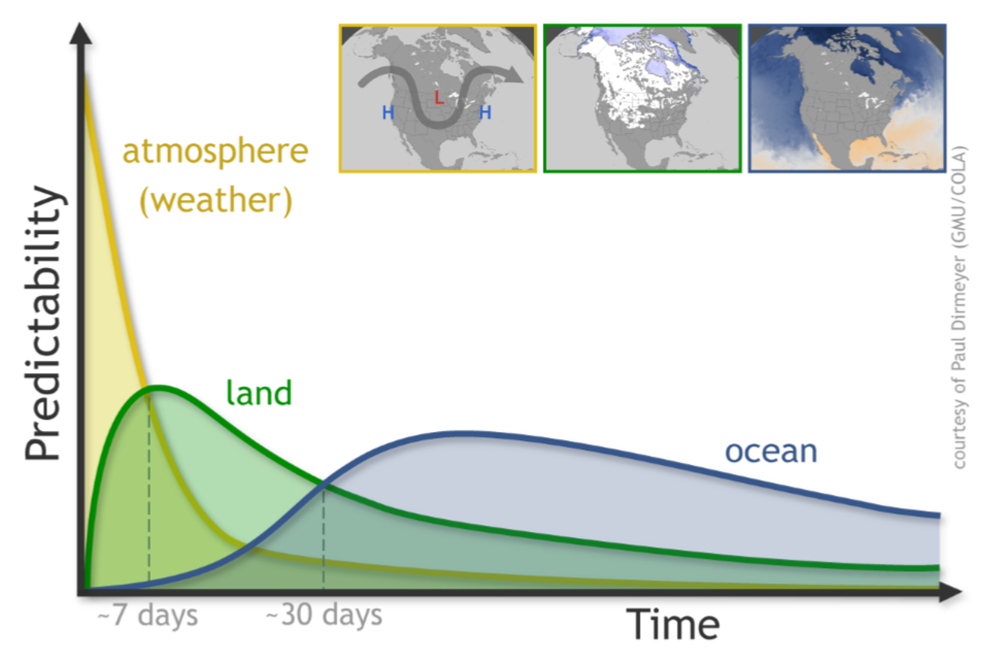
Figure 2. Impact of atmosphere, land and ocean on predictability as a function of lead time. This figure suggests that land is likely to play an important role for sub-seasonal prediction.
Proposed studies
This sub-project will work in coordination with the Global Energy and Water Exchange/Global Land Atmosphere System Study (GEWEX/GLASS), Data Assimilation and Observing Systems (DAOS), EartH2Observe and WGSIP SNOWGLACE to both investigate the fidelity of model representations of land-atmosphere interactions, and how S2S forecasts may be improved by taking better advantage of the information contained in land surface states. Several questions will be addressed in this sub-project:
- What is the impact of the observing system on land initialization and S2S forecasts?
- How well are the coupled land/atmosphere processes represented in S2S models?
- How might anomalies in land surface states contribute to extremes?
Investigation of the diurnal cycle would require at a minimum 6-hourly (and ideally 1-3 hourly) S2S model output for selected near-surface fluxes, states and 2-D atmospheric fields (e.g. PBL depth), but could greatly aid the identification of problems in forecast models and inform model development.
The possibility exists for setting up coordinated modelling experiments to investigate such questions with carefully-designed sensitivity studies, leveraging expertise gained by modelling efforts in GEWEX/GLASS and WGSIP. EartH2Observe has developed a multi-model land surface hydrologic analysis (Schellekens et al., 2017) that can serve as a validation dataset, or even a source of initialization fields for surface hydrologic variables provided the proper precautions are taken (cf. Koster et al., 2009). There are also current and planned field campaigns (e.g. LAFE, HyMex, RELAMPAGO, and a possible new North American water-related regional hydroclimate project in GEWEX) that could greatly inform model evaluation. The Local-Coupled modeling (LoCo) effort in GEWEX/GLASS has developed a number of metrics to assess coupled land-atmosphere behaviour in nature and models that can be brought to bear. Efforts to operationalize true assimilation of land-surface data have begun with snow cover and are extending to snow mass and soil moisture, with particular emphasis on remote sensing data streams. Vegetation properties attainable in real time from satellite are the next target (including leaf area index, greenness and other multi-spectral quantities) because they affect surface water, energy, momentum and carbon budgets as well as aerosols.